 Steve Taranovich
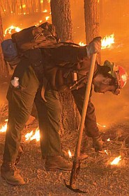
Image from NASA
Human health and welfare depends partly on our ability to understand and adapt to environmental changes; severe forest fires like those occurring in California today are a stark example. Viewing these fires from space are a great help to understanding and fighting the fires.
NOAA/NASA's Suomi NPP satellite observes the Earth’s surface twice every 24-hour day, once in daylight and once at night. In its orbit NPP flies 512 miles (824 kilometers) above the surface in a polar orbit, and circles the planet roughly 14 times a day. NPP sends its data once each orbit to the ground station in Svalbard, Norway as well as continuously to local direct broadcast users.
A stunning 3.1 million acres have burned this year in California alone (per CAL fire); this is up from a total of 2.5 million acres as of Wednesday, September 09, 2020. In addition, 805,314 acres have been lost in Oregon (State of Oregon Fires and Hotspots Dashboard, as of 9:30am EDT Sep. 11) and 500,000 acres (Northwest Interagency Coordination Center) in the state of Washington. Winds blowing through the west have been stoking fires and aiding the quick spread as can be seen in the growth of over a half million acres in less than two days. There have been 12 wildfire-related fatalities this year. Records have been shattered during this fire season and experts continue to blame drought, excessive heat and strong winds for this terrible life-threatening situation.
Earth’s climate continues to change and many scientists believe that these types of fire events will not only continue but will worsen. A predictive meteorologist for the National Interagency Fire Center, Nick Nausler sent this out on Twitter: "Multiple fires made 20-plus mile runs in 24 hours over the last few days in California, Oregon and Washington. Such distances traveled so quickly may not be all that rare in grassland fires. However, most of these fires are making massive runs in timber and burning tens of thousands of acres and in some cases 100,000-plus acres in one day. The sheer amount of fire on the landscape is surreal."
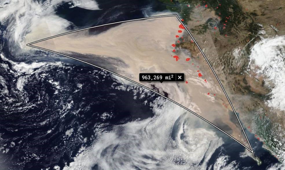
California’s fire seen from space: The square miles of smoke in the image below totals 963,269. That estimate has been computed using the measurement within the NASA Worldview application tool (Image from NASA Worldview)
NOAA/NASA's Suomi NPP satellite captured a series of images (made into an animated GIF) showing the winds changing direction on Sep. 06, 2020 when choking clouds of brown smoke began to billow and cascade into the Pacific Ocean. By September 10, these clouds of smoke had traveled over 1,300 miles.
Suomi NPP — the National Polar-orbiting partnership between NASA, the National Oceanic and Atmospheric Administration, and the Department of Defense -- is the first of a new generation of satellites that will observe many facets of our changing Earth, the satellite collects critical data to improve scientists’ understanding of long-term climate change and short-term weather conditions. With this satellite, NASA continues many important data records initiated by the agency's Earth Observing System satellites, monitoring changes occurring in the atmosphere, oceans, vegetation, ice and solid Earth. NASA's Earth Observing System Data and Information System (EOSDIS) Worldview application provides the ability to interactively browse over 700 global, full-resolution satellite imagery layers and later download that underlying data. Many of the available imagery layers are updated within three hours of observation, showing the entire Earth as it looks "right now.” Actively burning fires, detected by thermal bands, are shown as red points.
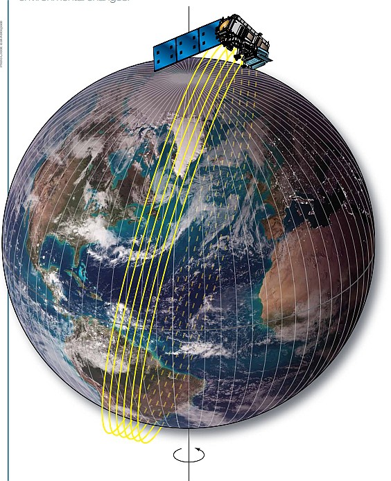
NPP, the size of a minibus, is in a polar orbit—circling the Earth from the North Pole to the South Pole and back about 14 times a day (Image Courtesy of NASA Worldview, EOSDIS).
On-board Instruments

NPP satellite instruments (Image from NASA)
VIIRS – Visible Infrared Imaging Radiometer Suite is a multi-spectral scanning radiometer that scans a 1,889-mile wide swath of the Earth (3,040 kilometers)
CERES – Clouds and the Earth’s Radiant Energy System is a 3-channel radiometer measuring reflected solar radiation, emitted terrestrial radiation and total radiation.
CrIS – Cross-track Infrared Sounder is a Michelson interferometer that scans about 1,367 miles (2200 kilometers) of the Earth’s atmosphere.
ATMS – Advanced Technology Microwave Sounder is a 22-channel passive microwave radiometer with a swath width of 1,429 miles (2300 kilometers).
OMPS – Ozone Mapping and Profiler Suite is an advanced suite of three hyperspectral instruments that measure ozone.
NASA’s satellite instruments are often the first to detect wildfires burning in remote regions, and the locations of new fires are sent directly to land managers worldwide within hours of the satellite overpass. Together, NASA instruments detect actively burning fires, track the transport of smoke from fires, provide information for fire management, and map the extent of changes to ecosystems, based on the extent and severity of burn scars. NASA has a fleet of Earth-observing instruments, many of which contribute to our understanding of fire in the Earth system.
Discussions
Become a Hackaday.io Member
Create an account to leave a comment. Already have an account? Log In.