Close
0%
0%

HFOS

A federated crew toolset for navigating, collaborating, resource management, IoT and tons of other things.

Similar projects worth following
What started out as a simple robotic remote control system, quickly grew into a mature approach to maritime navgiation. Since then, it has again come a long way and is now slowly, but steadily developing into a new kind of user and machine experience.

What's this?

HFOS is supposed to run on small energy efficient machines (RPi etc) and provide a host of services in an offline-compatible, yet federated (think of freifunk/mesh ;) way, but i recently found out, it should work nicely on your Android device as well.


It basically consists of a backend (Python) and a frontend client app (HTML5) and focuses on small group collaboration - the missing parts for better teamwork without the need to offload your data to anyone else.

Modules
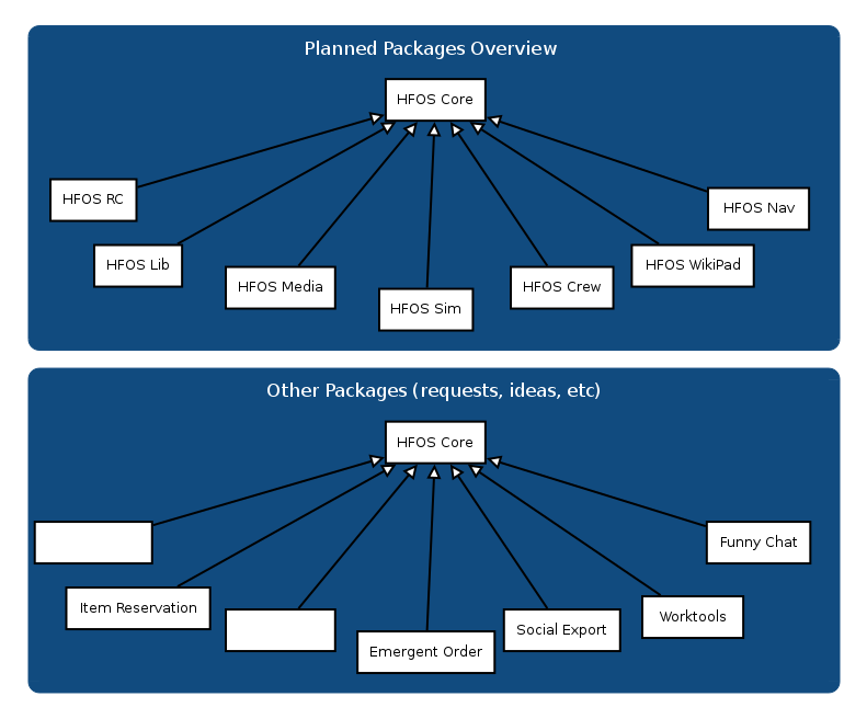
Planned Module List

Some of the goals i have on my list are already partially working:

  • Sensor evaluation with fancy charts, graphs etc - originally aimed at sailors and their ship's sensors
  • Maps - again, one of the heavy topics because of the sailor-orientation, it will do waypoint planning, weathermaps (grib), and a lot of other goodies, offline via caching, free full vector maps will join soon, too.
  • Project management - not so much focused on software but actually on my private needs - and yours?
  • Shareable item reservation for rooms, tables, working equipment etc - need this for c-base, the local hackerspace
  • Library management for books and similar media. Small, not so heavyweight as other solutions but still useable for a federated hackerspace library, again - i plan to use this for c-base's c-lib
  • An etherpad + wiki collaboration tool as well as a chat module (I don't like all these commercial, proprietary chat systems, but irc & jabber won't do for most people either :-/ )
  • Switchboard for simple on/off switches
  • Simple and modular "If-this-then-that"-like control system
  • Garden watering automation
  • Robot remote control - we've already tested a lot with our robotic vessel MS0x00 ( https://duckduckgo.com/?q=ms0x00&t=ffsb&ia=videos ) which is now and then being used for automatic water depth and other measurements

Since the system is being transformed into a modular, extensible framework, a lot of other stuff will join - writing your own modules is really easy!

Development

1.1

The newest version is rather usable! There's still a lot of important stuff missing (e.g. data migrations), but you can already dive in and test it. I've simplified the installation method, so essentially you now only have to grab the source, install a few distro packages and run the installer. Distribution-aware packages are being prepared, i hope to get this done by 1.2.

1.0

Since I work more or less alone on the project and because I am currently preparing the release of a rather major overhauled version (1.1, sporting a modular component/app-system and a lot of frontend technology upgrades, release is planned for the next few days), the project is currently not in a really useable state.

Help out!

So, I'd be more than happy to welcome new HTML5 (Angular) and Python developers to join the fun!
Also, folks who can happily indulge in writing really complex application testing systems ;)

Check out the repository on github: https://github.com/hackerfleet/hfos and join us on #hackerfleet@irc.freenode.org :)

Cheers!
riot

Screenshots
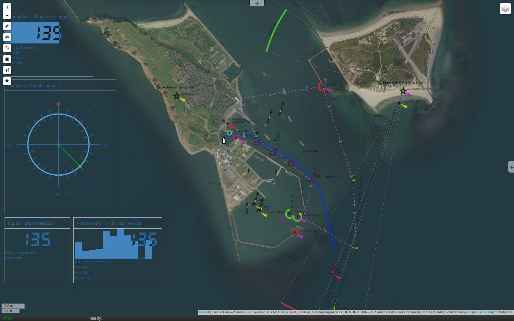
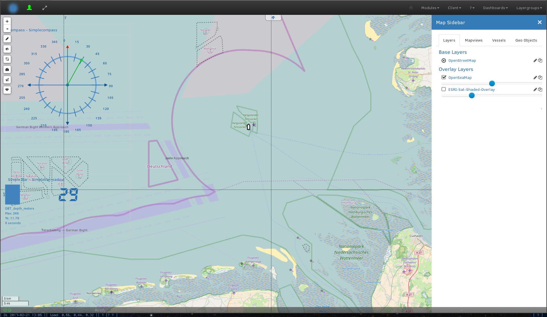
Map showing ESRI Satellite imagery, Openstreetmap and Openseamap along with the new overlaid Dashboard (Simulation mode) with a short route included.
Newly added Layer selector and a nice (adaptive) coordinate grid have been added.
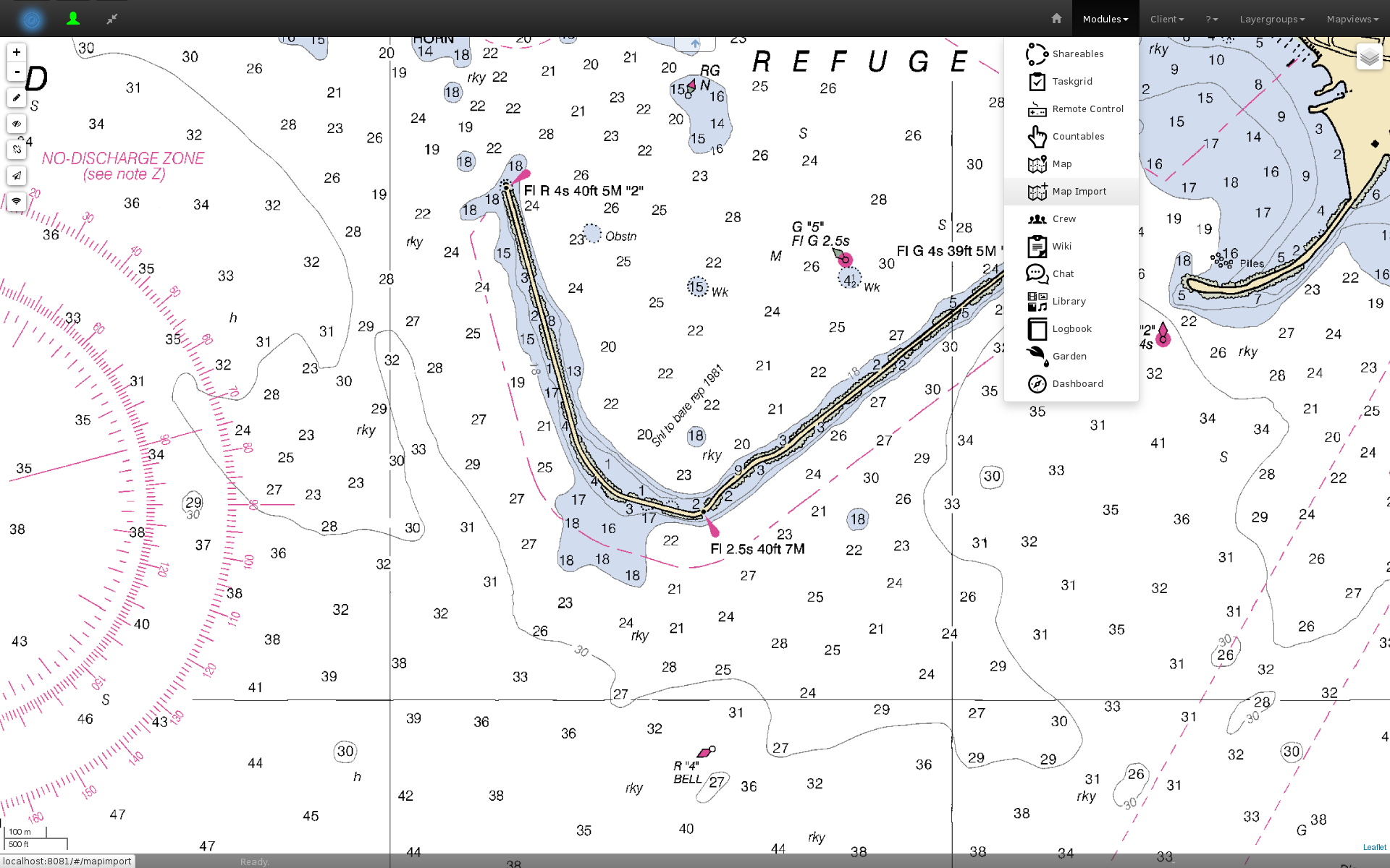
You can import Rastercharts (KAP, more on request) into the system and use them alongside the other data sources.

We also added a shareable resource management/allocation module, so you can coordinate multiplayer usage of your boat, soundlab or whatever :)

temperature_and_hg_europe_and_riots_baltic_route.png

An earlier view of a chart with a few waypoints and an Openweathermap temperature map as overlay. We'll refine this to allow usage of grib-format weather data, soon.

Portable Network Graphics (PNG) - 1.54 MB - 12/20/2016 at 17:07

Preview

2016-08-29_ShareablesCalendar.png

This is, how the shareable resource reservation overview looks like. Primary uses include vessel reservation for shared yacht ownership groups or managing the workshop your sailors club has, etc. You can register any object, be it a room, vessel or just a very coveted tool!

Portable Network Graphics (PNG) - 648.50 kB - 12/20/2016 at 17:05

Preview

2016-09-02_Map_with_dashboard.png

I have been experimenting (not in the master branch yet) with a dashboard overlay - so you can soon see al the yacht performance parameters while checking out the map. We'll add maps in the dashboard as well, so the reverse is possible, too :)

Portable Network Graphics (PNG) - 260.90 kB - 12/20/2016 at 17:03

Preview

2016-12-18_first_imported_rasterchart.png

View of a rendered KAP raster chart file in HFOS' map module. Since we're using GDAL, it supports almost all of the (proprietary) raster chart formats. You can simply upload them in the application and they will be rendered as tilemap for use in the map viewer. Caution, takes ages on a Raspberry Pi! But you can prerender them on another, faster machine.

Portable Network Graphics (PNG) - 400.61 kB - 12/20/2016 at 16:59

Preview

  • 1
    Step 1

    Check out the official (more in depth) howto at readthedocs or on github. If you run into troubles, contact us by mail, irc or simply open an issue on our github issue tracker. Our contact info is listed in the howto, as well.

    Grab an embedded system - a Raspberry Pi will do, but something faster -> More fun! Of course, you can also use the machine you're using to read this or any other.

  • 2
    Step 2

    Install a rather recent version of Debian, Arch or whatever you think you can handle on the RPi

View all 7 instructions

Enjoy this project?

Share

Discussions

KingMackerel wrote 05/25/2021 at 20:23 point

Riot this looks like a great project! Are you still working on it? 

  Are you sure? yes | no

riot wrote 12/20/2016 at 17:12 point

This december is "Month of new chart features" - i've been adding raster chart support recently, next up is grib data import, so you can check out the weather layered above your paper charts - digitally :>

Also, Hackerfleet is proud to be at the 33c3. If you'd like to meet us, chat and collaborate, ping me by mail (riot@c-base.org) or irc (#hackerfleet on freenode). 

I'll do a lightning talk about HFOS, as well.

See you there!

  Are you sure? yes | no

riot wrote 09/03/2016 at 21:42 point

There will be a Hackathon at the c-base in Berlin from 8.-9. this month. Join us from 11 am. BYO-BBQ afterwards/during the event!

  Are you sure? yes | no

riot wrote 07/30/2016 at 11:26 point

A few updates from the ongoing 1.1 release cycle:

* Docker integration is now updated, i hope to get this used in Travis for CI as well.

* Map has been extended to work well with shared mapviews and layer(-groups)

* Other Vessel (including their radio-range) display is being reimplemented 

* The Wiki will get a WYSIWIG editor and a templating system

  Are you sure? yes | no

riot wrote 06/21/2016 at 10:08 point

The release of 1.1 is nearing. Check out the milestone notes:

https://github.com/Hackerfleet/hfos/issues?q=is:issue+milestone:"Release+1.1"+label:enhancement

The biggest improvement - or the one with the biggest impact - is probably the new modularization concept. You can now bundle complete features into components. Those can have their own schemata, provisions, documentation and backend as well as frontend components.

Most of the other work has gone into upgrading the frontend to a better structure and library stock, so it loads and operates faster and now accomodates for the frontend component handling.

The release is planned for 24.6., so check it out! (And then fork it and improve it ;)

https://github.com/Hackerfleet/hfos

  Are you sure? yes | no

riot wrote 07/30/2016 at 11:24 point

The release date has been hit hard, so i removed it. Fret not, the release is nearing ;)

  Are you sure? yes | no

Similar Projects

Does this project spark your interest?

Become a member to follow this project and never miss any updates