 aerospark
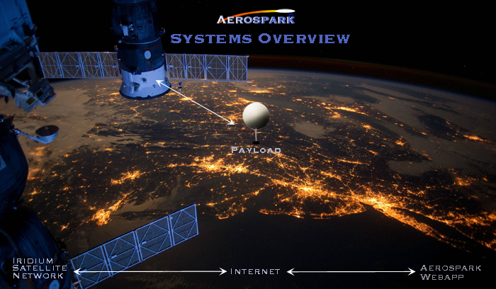
Figure 1: Major Systems Overview Graphic
This log is just to provide an overall description of why I decided to select the systems in Figure 1 for this project.
Payload: When I started my first HAB project last summer, it was partly to just do a fun project with a microcontroller, and the Raspberry Pi has always been quite pleasant to work with. I'd like to eventually use this project to promote STEM education to public school students, so the Raspberry Pi seems like a good fit for the job.
Another realization I made last summer, was that an amateur radio licence is required for a majority of high altitude balloon projects. The ones that don't are very simple and don't really have much functionality unless you add your own microcontroller anyways. So by using the RockBLOCK Iridum Unit, Aerospark Pi Shiel, Batteries (2x 9V), Camera, and Rocket. One battery charges the Pi/RockBLOCK/Camera, and the other is used for auxiliary power (i.e. payload heating, rocket ignition, cable cutdown, parachute deployment charge, etc.). The RockBLOCK Iridium Unit is plugged into the Raspberry Pi's USB port and allows for communication with the Iridium Satellite network (approximately every 1 minute for up to 350 bytes of data).
Iridium Satellite Network: I really spent a lot of time debating the merits of Iridium vs. APRS, but it came down to the ground station. I knew I was going to have to spend a couple hundred on some ground equipment for APRS, or i could throw that down upfront on an Iridium based tracker and build a nice website to read the data in.
Aerospark WebApp: The pleasure of pushing a button to control some physical object is awesome, and if you have every launched a rocket with one of those big red buttons, you know what i'm talking about! I really wanted to bring this feature into HAB, and make tracking/monitoring as easy as possible by interfacing google maps and sensor data to the website.
Discussions
Become a Hackaday.io Member
Create an account to leave a comment. Already have an account? Log In.