 alexwhittemore
As a team, we're still in the early stages of figuring out all the pain points of SuperAdobe construction and making a formal assessment about where lies the best value for money in addressing those pain points.
Even still, we've already learned some extremely interesting details of the process we wouldn't have expected, and naturally, we've got some ideas of tools we might build to address them.
For instance - you'd think (or I would, anyway) that the most labor-intensive (specifically time-intensive) part of building a structure from sandbags full of earth would be actually shoveling earth into those bags. Surely, you've got a lot of bag volume to pack, and going back and forth over and over with a coffee can must take a lot of time? As it turns out, talking with Marco at CalEarth, we found out that the biggest bottleneck of the process usually seems to be the person whose job it is to map out where the next bag goes.
Under the current process, this person uses chains and trigonometry to calculate how far the next bag layer is supposed to overlap the first one. But with a handful of people doing the easy and relatively rapid task of filling and laying bags, this one expert tasked with QC tends to get overwhelmed. In addition, it sounds like builds often end up wasting time on compass errors that require dismantling work to go back and re-do it. For example, if the chain gets twisted up and therefore shorter, the team may place even a layer or two of bags in the wrong position before realizing the error.
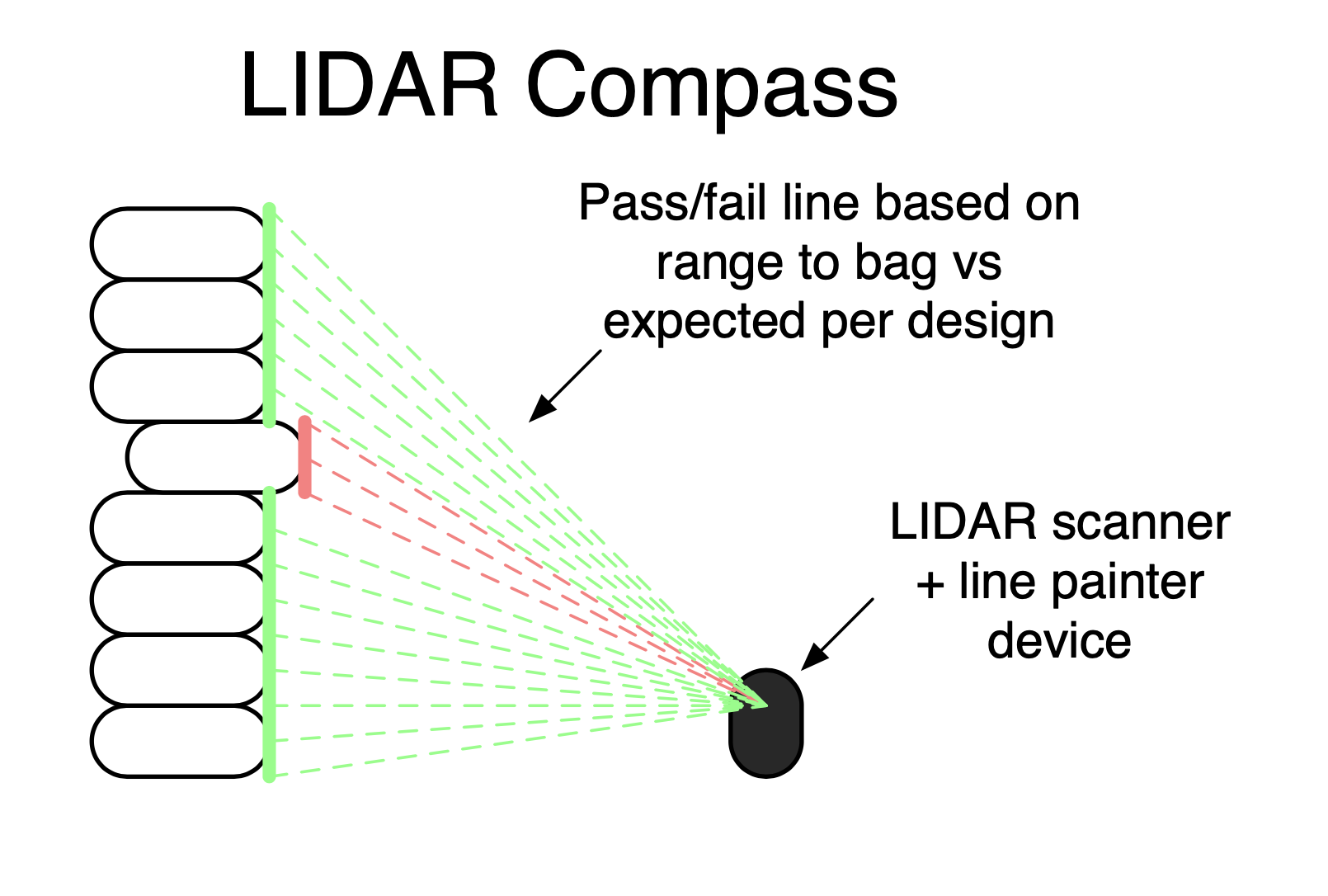
Being an electrical engineer by trade (and one who's used LIDAR professionally quite a bit lately), the first thing that jumped to my mind was a laser scanning system. The proposed device would sit in the middle of the foundation area and measure range on a circle, sweeping out a vertical cross section of the structure under construction. Bags that have already been placed will show up on the scan line, and the range to these bags will either be correct or incorrect based on a profile loaded into the scanner. For feedback, the same scan head could also EMIT a laser, perhaps with a green line where bags are positioned at the correct range (give or take some error) and a red line where they're incorrectly placed. We call this idea the LIDAR Compass.
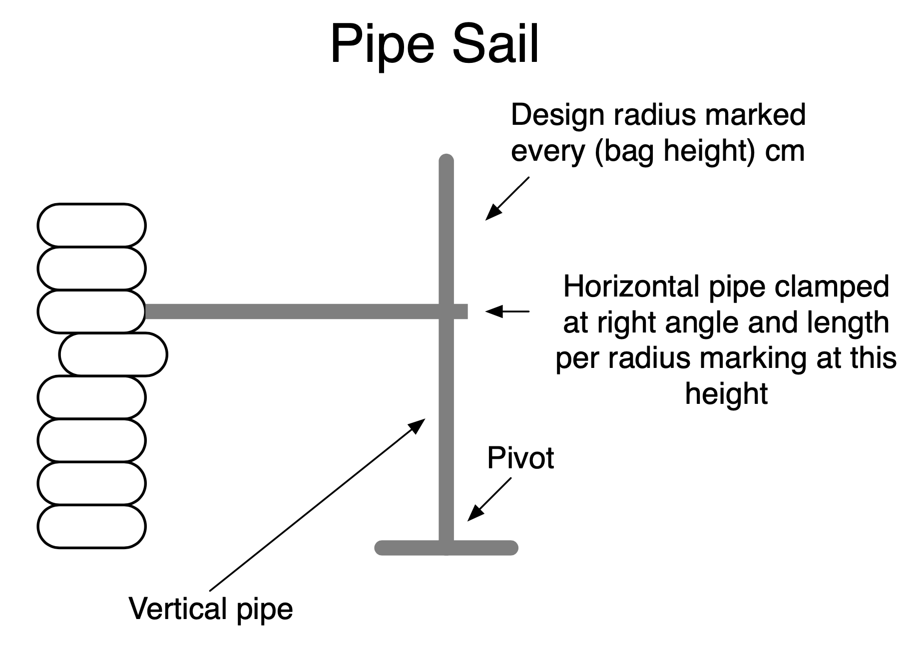
As it turns out, CalEarth has already come up with their own lower-tech solution to this problem, and sometimes uses what they call a "sail." This is a big sheet of wood cut to same profile as the inside of the finished dome, which can be rotated around a mast on the center axis.
The problem they've run into with the "sail" concept is that actual structures often have protrusions through the walls while being constructed, such as forms for windows or vents that poke into the inner volume of the finished dome. These pose an obstacle for the mast, since it can't sweep through space occupied by a protrusion, and some designs mean that the sail can simply never rotate in a full circle.
A relatively basic low-tech improvement to the "sail" tool we call a pipe sail. Instead of attaching a full-size profile of the dome to a pivot we could put just a vertical pipe on the center axis, with pre-marked radius measurements for every bag layer going up it. For every layer, builders clamp a shorter pipe at a right-angle, using a tape measure to set the length per the radius marking under the clamp. This doesn't completely solve the obstruction issue, but with with a simple chalk marking on the radius pipe, it could be unclamped and re-clamped at will to pass any obstructions.
Of course, there's much work still to be done to validate these ideas!
Discussions
Become a Hackaday.io Member
Create an account to leave a comment. Already have an account? Log In.