Hardware
o iPhone 6S
o Raspberry Pi Zero with wifi
o Battery Bank
o 1090Mhz Antenna
o Flightaware Pro+ dongle
o Raspberry Pi Zero USB Hat
o cables (2 x Micro USB, Lightning cable, Antenna Coax)
o GPS USB Dongle (unless I can hack the iOS GPS)
o Switch
Progress So far.
Works fine with the Pi Zero built using the standard PiAware v4.0 build on a 32Gb Micro SD Card.
Added the Flightaware dongle to the pi hat and all works OK. Utilising the HotSpot capability, I can reference the Pi via the Hostname.local:8080 on the iOS browser once connected via Hotspot.
Added the Wifi details of the Hotspot to the piaware-config.txt file on the /boot of the SD Card.
Tracks flights OK (when outside the car!)
Stayed connected for a couple of hours (Hotspot) (even when in the boot of the car) and low drain on the battery bank.
Next Steps.
Ordered a GPS Dongle (AU$12 off AliExpress)
Add a on off switch to the Pi Zero. Code up a shutdown script.
Design & 3D Print a suitable case (may just use a tupperware container for the moment.)
Learn what data is being sent via the dump1090-fa. Code something to alert. Perhaps use Slack as the messaging (easy curl script) initially.
Once dongle. Look at installing GPSD on the Pi Zero.
Determine how to dynamically pass the current location.

 Sean Hodgins
 tomwsmf
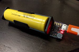
 Patrick Van Oosterwijck
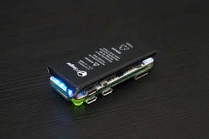
 Jdaie
Jdaie