equityengineers
Today for land surveyors to find a point of beginning for their field survey they must rely on finding existing monumentation with established location data. Locating these monuments is a tedious and time consuming process because most of these monuments are located at or below the surface of the earth and therefore they are not visible at any significant distance. The reason these monuments are so located is to reduce the chances that they would be disturbed in which case would render them useless as survey monuments.
In order to find a point of beginning for their field survey they must rely on finding existing monumentation with established location data. Locating these monuments is a tedious and time consuming process because most of these monuments are located at or below the surface of the earth and therefore they are not visible at any significant distance. The reason these monuments are so located is to reduce the chances that they would be disturbed which would render them useless as survey monuments
If instead of burying survey monuments; if coordinates could be established on existing fire hydrants surveyors would have a highly visible permanent monument that would eliminate much of the field work associated with locating a useable point of beginning for their survey.
Fire hydrants are usually located less than 1000 feet apart and are highly visible. They are much more stable than underground monuments and they are rarely disturbed without someone in authority being notified.
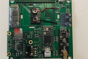
The system is made up of
A Global Positioning System Antenna transceiver
A 360 degree optical reflector prism
A hydrant top mounting bracket
A global positioning system antenna transceiver is mounted on to a 360 degree optical prism the the prism and the GPS+GLONASS antenna transceiver are mounted on a bracket that can be attached to a fire hydrant.
How it works
The GPS+GLONASS antenna transceiver receives radio signals from a constellation of earth orbiting satellites. Those signals are collected analyzed and computed to create coordinates that establish the antenna transceivers location on or above the surface of the earth. When the GPS+GLONASS antenna transceiver is located on top of an existing fire hydrant the coordinates of the antenna transceiver can then be used to establish the location of the fire hydrant.
By mounting the GPS+GLONASS antenna transceiver on a reflective prism this allows optical land surveying instruments with laser ranger finders to measure distance and relative angle between the point of beginning (fire hydrant) the surveying instrument and the other points to be surveyed.
The GPS+GLONASS antenna transceiver and the reflective 360 degree prism and mounting bracket would be mounted on the top on an existing fire hydrant the GPS+GLONASS antenna transceiver would be turned on and would start collecting signals from the GPS+GLONASS satellites in earth orbit and the terrestrial broadcast GPS+GLONASS signals. Once these signals have been received and resolved to establish the location of the subject antenna transceiver. An optical land surveying instrument can then be deployed to an appropriate location and using the calculated location of the fire hydrant mounted GPS+GLONASS antenna transceiver as the point of beginning proceed with collecting the survey related field data.
This process would then establish the subject fire hydrant as a highly visible, permanent monument for all future surveys in this area, eliminating the issues around locating monuments hidden at or below the earth’s surface.
The location data of existing fire hydrants has many uses in Geographic Information Systems (Google Earth), emergency response and water and utility management.
As a field data collection devise it could easily be adapted to record location data of any natural or man made feature on or above the surface of the earth.

 Lex Kravitz